
Home
Cruise
Observatories
Operations
Student Projects
Gallery
Poetry
We left Newport, Oregon at about 1500h on July 29. The calculated transit time to Axial Seamount is about 20 hours at 11 knots (nautical miles per hour). So the day started somewhere in the middle of the Juan de Fuca Plate at one minute after midnight with the ship headed slightly north of west, bound for the largest active submarine volcano east Hawaii and north of Baja California: Axial Seamount
An Introduction to Axial Volcano (a Growing Seamount)
Axial Seamount was named in the early 1980s by NSF-supported researchers studying basaltic rock chemistry along the entire Juan de Fuca Ridge. The Ridge is a 300-mile long volcanically active suture where the Pacific and the Juan de Fuca Plates are pulling apart at about the speed that your fingernails grow ¬— six centimeters a year. Episodically, magma (soon to become lava when it erupts) flows upward into the opening between the plates and creates new ocean crust. Most of the Juan de Fuca Ridge is a fairly narrow, volcanically active ridge that rises above the surrounding seafloor between 200 and 400 meters.
Axial Seamount is somewhat analogous to Iceland, stands nearly 1000 meters above the surrounding abyssal plain, and is centered directly on the Juan de Fuca ridge. Axial is very active seismically and volcanically. In terms of hydrothermal activity, it is a perfect and somewhat intensified natural laboratory in which to study fundamental earth processes in near real-time with the Regional Cabled Observatory.
Why Axial?
We have chosen to focus on Axial Seamount as a vigorous submarine volcanic system because it is the location of so much activity and because of its placement a very active spreading center. Therefore, to a first order, it represents an intensified potential laboratory of processes that operate worldwide along the 70,000 km long Mid Ocean Ridge System. By choosing such a logistically accessible, especially intensified volcanic system that is representative of the global rift system, we will be able to examine in great detail the interplay among the basic earth processes involving plate tectonics and volcanism, as well as the manner in which these processes interact with the overlying ocean.
End of the Transit, Beginning of the Axial Survey Work
Little of interest happened until about noon on Wednesday, July 30, when we slowed down to about 8 knots to conduct an EM-300 multibeam survey of the eastern flank of Axial Seamount. This new map will allow us to place the Sentry high-resolutions surveys and the TowCam digital photography work into the most current context. We will also use the new map to examine any changes that may have occurred in eruptive behavior of the volcano since the last survey by NOAA scientists in 2002. Subtracting one map from the other allows scientists to identify where recent eruptions, which might otherwise go undetected, may have continued to build the volcanic edifice in the interval between the mapping activities, that is, lava-like mounds in the 2008 map that do not appear in the 2002 map are likely to have been eruptions during the 6-year interval. It is a form of submarine “sleuthing” that would make Sir Arthur Conan Doyle envious. The technique was developed by Bill Chadwick and Bob Embley at NOAA-PMEL in Newport, Oregon. Obviously, the last thing we want to do is lay the regional observatory cable or locate the nodes in places where very recent eruptions have occurred.
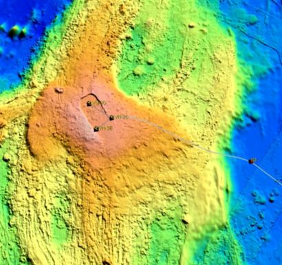
Thompson Basin: a Home for Node 3
There is a small volcano just to the east of Axial that has been labeled Thompson Seamount after the famous UW Oceanographer, Thomas G. Thompson, for whom our ship was also named. The small basin to the west of Thompson Seamount, at the eastern base of the much larger Axial Seamount, is the optimal location for the long-term residence of the major Primary Node for Axial, Node 3. That part of the decision process seems easy. The difficult problem we face has to do with getting the connecting cable from Node 3 in Thompson Basin, up to the crest of Axial Volcano at a location that allows us to work within the caldera (an eruptive depression in the top of a volcano) where most of the action on Axial Seamount is liable to be located. Therein lies our dilemma, and our activities over the coming four days will address the best location for a secondary node along the edge of the caldera, as well as the most-rational, least-risky, path from N3 to the more remote node at the caldera’s edge.
The Dilemma of Novel Approaches
This issue of how to instrument an active volcano is, of course, a serious challenge for several reasons: 1) OOI scientists and engineers want to have this cabled and power communications node endure on Axial for a long time – decades – and therefore we do not want to place it in any obvious jeopardy; 2) we are aware that normally the large, global telecommunication corporations that know the most about laying submarine cable on the seafloor are of the general opinion that one should not lay a communications cable over an active volcano. This makes evident sense if your goal is to optimize the investment in high-speed communications between humans, most of whom live on continents. Yet if we want to understand underwater volcanoes, that is exactly where the cable and the equipment must go, once we have exercised all due caution; 3) none of the marine scientists involved have ever laid a cable on a volcano either, despite the fact that we understand quite a bit about submarine volcanism. So we have no experts on this volcano-cable issue to turn to. Hence this is a highly practical research cruise that will identify potential locations, cable paths, and strategies that will minimize risk to the long-term infrastructure. As a community we are learning to do something no one has done before. (Continued in July 30, Daily Log, Part 2: If Science were Music...)
Contributed by Chief Scientist John Delaney
