Home
Cruise
Observatories
Operations
Student Projects
Gallery
Poetry
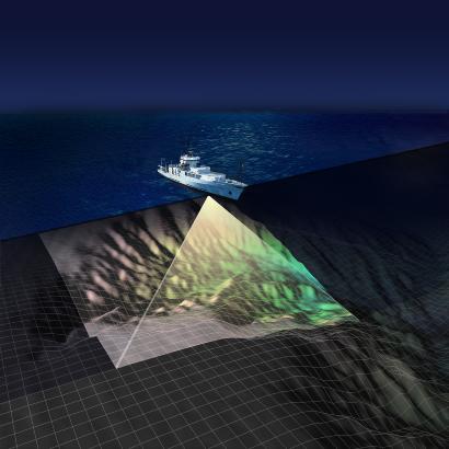
The primary purpose of this cruise is to map the seafloor in two areas of high scientific interest within the National Science Foundation’s Ocean Observatories Initiative.
Mapping Areas of High Scientific Interest
The primary purpose of this cruise is to map the seafloor in two areas of high scientific interest within the National Science Foundation’s Ocean Observatories Initiative. One area is near Hydrate Ridge, just off the central Oregon coast due west of Newport, Oregon, and the other aea of interest is near Axial Volcano, about 250 miles west of Newport. Existing maps are inadequate for the purposes of safely installing primary nodes on the main cable in the portion of the observatory network known as the Regional Scale Nodes, which is associated with the Juan de Fuca tectonic plate. These nodes will adapt high-voltage power and high-bandwidth communications to levels and formats useable by scientific instrumentation. Installation is likely to begin in 2010.
Activities on Cruise
Activities on this Insite08 cruise will include the use of the EM300 multibeam sonar, which is mounted on the hull of the University of Washington Research Vessel Thomas G. Thompson. The EM300 is used to create maps of the seafloor that provide an overview of the areas of interest. High-resolution mapping will be accomplished using the state-of-the-art Autonomous Underwater Vehicle Sentry in its first formal deployment on an oceanographic research cruise. A deep-towed digital camera, TowCam, will be used to photograph detailed characteristics of the seafloor to ensure that no hazards such as submarine landslides will occur in the selected area.
Why do we Need to Map the Seafloor?
Because the RSN system is designed to last 25 years, the primary nodes and backbone cable must be installed in seafloor areas that are relatively benign: the node sites must be relatively flat and the route of the cable should not pass through steeply angled portions of the seafloor. In addition, areas to avoid include sites where mapping reveals past undersea landslide activity. Landslides are capable of severing a telecommunications cable.
Dates of Cruise
Cruise dates: 22 July to 5 August, 2008, Seattle to Seattle, with a mid-cruise port call in Newport, Oregon